Local, National and Historical Maps
CAISTER HOLIDAY PARK Sat: NR30 5NH
You are here: Home >
Shopping > Maps
FOYLES BOOKSHOP
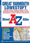
A-Z Atlas of Great Yarmouth
The A-Z Street Atlas of Great Yarmouth and Lowestoft also covers Beccles, Belton, Bungay, Caister-on-Sea, Gorleston-on-Sea, Hemsby, Hopton on Sea, Kessingland, Loddon, Martham and Southwold. Foyles is the world's most famous bookshop with over one hundred years of trading history. From five floors at the London flagship store Foyles stock an unparalleled range of 250,000 different titles in fifty-six specialist departments. Foyles offers delivery to home, business or bookstore, an out-of-print and secondhand offer via the Marketplace and a Click & Collect option for instore stock items. Foyles now also have an ever-increasing number of eBooks available for immediate download.

ORDNANCE SURVEY CAISTER MAPS
Historic and Leisure Maps
Ordnance Survey is the national mapping agency of Great Britain and is the leading provider of paper mapping products and outdoor essentials. The brand is highly regarded by ramblers, map lovers and all those who like to spend time outdoors. The strength of the geographic data produced by Ordnance Survey has fostered a strong reputation amongst loyal customers who have been using Ordnance Survey Explorer and Ordnance Survey Landranger maps for years.